How GPS Maps Are Made
GPS maps are produced using specially equipped vans which drive over the entire road
system to capture the information necessary for this operation. Each van is fitted with
- high resolution Digital cameras
- laser equipment to measure distance
- a GPS system to accurately log the map co-ordinates
As the van is driven along the road, images from the cameras and the differential GPS system are stored on local hard disks. At the end of each day, this information is transmitted back to the office, where it is used to produce new maps or update any changes to existing maps.
This is an ongoing process as the road network is constantly changing.
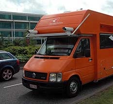
Stijn Ulenaers and Gudrun Vanlaar are a Belgian couple employed by Tele Atlas as surveyors, to produce digital maps for satellite navigation devices. The video clip shown below is a BBC News item showing them capturing the information to be processed into maps.
This needs a flash player installed to display properly.
![]()
See the original news item at
bbc.co.uk.
Further Information

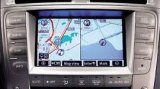
How GPS works
Install SatNav on your carputer
![]()
Alternative GPS Systems
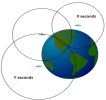
Trilateration. The principle behind the calculation of GPS map co-ordinates.
« Return to AUTO GPS from GPS MAPS
my-car-computer.com
![]() Subscribe To
Subscribe To
This Site